
Home > International Partnerships > Collaborative Research > Quasi-Real-Time Monitoring of a Forest Fire in the Asia Pacific Region Using the Himawari-8 Meteorological Satellite
Update:March 2, 2020
Main content starts here.
Quasi-Real-Time Monitoring of a Forest Fire in the Asia Pacific Region Using the Himawari-8 Meteorological Satellite
1. Partners
Institute of Industrial Science, The University of Tokyo, Japan
Faculty of Life and Environmental Sciences, University of Tsukuba, Japan
Center for Ecosystem Studies, Mongolian University of Life Sciences, Mongolia
2. Research Period
FY 2016 Grant for Promoting Science and Technology in Aerospace Field (Ministry of Education, Culture, Sports, Science, and Technology, Japan)
3. Lead Researcher
MATSUI, Tetsuya
4. Background
A wide range of forest ecosystems are distributed from the boreal zone to the temperate and tropical zones in the Asia Pacific region. In the taiga of Far East Asia, the vegetation dynamics are largely regulated by forest fires caused by lightning strikes, which are considered to have facilitated the regeneration of this forest type. Furthermore, in tropical peat forests, such as occur in Indonesia, ground burnings as a result of illegal logging spread to the forest floor, which is considered to have resulted in numerous carbon stocks being lost from the peat bogs and emitted into the atmosphere. Therefore, an understanding of the quantitative dynamics of the vegetation, soil, and water on the land surface is considered important for making impact assessments for forest ecosystems. However, such ecosystem changes remain unclear in the transitional zone between the steppes and forests in Mongolia.
5. Research Goal
This research project was a sub-project of a larger project being led by The University of Tokyo that was investigating the establishment of a technology for monitoring forest fires in the Asia Pacific region in quasi-real-time using the Himawari-8 meteorological satellite. The objectives of this sub-project were to accumulate quantitative data on the in situ process that occurs during forest vegetation recovery and to survey the actual situation of the vegetation at a forest fire site in northern Mongolia.
6. Research Strategy
To quantitatively evaluate the recovery of vegetation after wildfires and to assess the impact of wildfires on coniferous forests in the semi-arid area, we conducted vegetation surveys at wildfire sites in northern Mongolia, the majority of which were in coniferous forests. At each site, we recorded the vegetation composition and structure and also measured the soil moisture content by installing a field server. In addition, we conducted a vegetation survey in European red pine (Pinus sylvestris) forests and a surrounding forest fire site in northern Mongolia, which is the southern limit of the taiga forest, and installed soil moisture meters at these sites to record the soil moisture contents. We used the recorded soil moisture content data to analyze seasonal changes in water availability, and clarified the relationship between vegetation recovery and the soil moisture content. In addition, we conducted a computer simulation to quantitatively determine how the biomass and structure of the vegetation changed before and after the forest fire(s).
7. Scientific Achievement
This study examined vegetation recovery, the soil water contents, and satellite images to detect the exact timing of forest fire(s) at a burned site in northern Mongolia, as well as the species composition and vegetation recovery, biomass changes, and carbon emissions. Satellite data showed that forest fires occurred at this site in 1998 and 2009, which resulted in the tree species composition primarily changing from mature conifer forest (Larix and Pinus species) to young deciduous broadleaved forest (Betula and Populus species) (Fig. 1). The soil water content was constantly low during the growing season (0.052–0.086 m3 H2O/m3 soil) (Table), and the forest biomass was reduced to one-third (75–20 t/ha) after the fires (Fig. 2). The Yasso07 carbon emission model showed that coarse woody debris of Pinus spp. will continue to emit carbon for the next 200 years as a result of these fires (Fig. 3).
Each tree was classified as dead or alive and was placed in one of the following three groups: (1) died owing to the forest fire, (2) survived the forest fire, and (3) newly emerged after the forest fire. The diameter at breast height (DBH) of some of the dead trees that had either been cut down or burned to the ground was estimated from relationships between DBH and the dominant DBH (D0), and the biomass of each tree was estimated on the basis of DBH measurements relative to the specific allometry formula for that species. In addition, the year in which each fire occurred was determined using satellite images such as Landsat, allowing us to estimate the change in forest biomass in response to the forest fires.
The forest biomass in the study plots changed dramatically from ca. 75 t/ha before the fires to only ca. 20 t/ha after the fires. Furthermore, only a small amount of the biomass recovery was attributable to new tree growth after the fires. These findings suggest that it is important to use a combination of satellite images, field survey, and model simulation to examine the impacts of forest fires on vegetation.
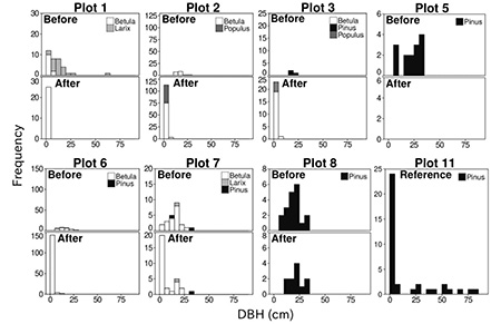
Fig. 1 Changes in the size distribution and composition of canopy tree species in each plot. For plots 1–8, the estimated size class frequency distributions of tree individuals before and after the forest fires are shown in the top and bottom histograms, respectively. Plot 11 represents a reference site with little evidence of fire. DBH, diameter at breast height (Matsui et al. 2018).
Table Soil moisture contents (m3 H2O/m3 soil) at the study sites
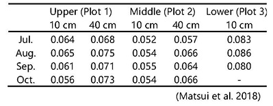
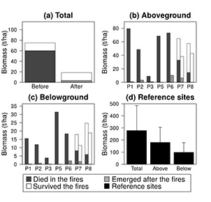
Fig. 2 Estimated (a) total, (b) aboveground, and (c) belowground biomass at the study sites, and (d) biomass at the reference sites. In (b) and (c), the pairs of bars for each site represent the biomass before (left) and after (right) the fires (Matsui et al. 2018).
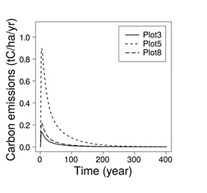
Fig. 3 Simulated annual carbon emissions (tC ha−1 yr−1) through time (years) as assessed by the Yasso07 model (Matsui et al. 2018).
8. Applications
The results of this study will be reported by the Mongolian University of Life Sciences to the Ministry of Natural Environment and Tourism, Mongolia.
9. Publications
Matsui, T. Hirata, A., Saito, T., Tamai, K. et al. Biomass comparison of coniferous forest before - and after - forest fires in northern Mongolia. IIS Forum Bulletin, 25, 11-14. (2017) (Non Refereed)
Nakazono, E., Takeuchi, W., Matsui, T., Hirata, A., Saito, T., Tamai, K., Kamijo, T., Sumya, O. & Undarmaa, J. Monitoring vegetation recovery of forest fire by MODIS in northern Mongolia. Bulletin of 2017 Japan Society of Photogrammetry and Remote Sensing, pp. I-2, Institute of Industrial Science, The University of Tokyo. (2017) (Non Refereed)
Nakazono, E., Takeuchi, W., Matsui, T., Hirata, A., Saito, S., Tamai, K., Kamijo, T., Oyunsuvd, S. & Jamsran, U. Tracing of the vegetation recovery by MODIS and Himawari 8 after the forest fire in northern Mongolia. 38th Asian Conference on Remote Sensing, New Delhi, India. (2017) (Non Refereed)
Matsui, T., Saito, S., Tamai, K., Hirata, A., Kamijo, T., Motoe, D., Shitara, T., Oyunsuvd, S., Jamsran, U., Kominami, Y., Nakazono, E. & Takeuchi, W. Comparison of forest biomass before- and after- wild forest fires in the conifer forest in northern Mongolia. Kanto Journal of Forest Research, 69, 59-62. (2018) (Refereed)
Copyright © Forest Research and Management Organization. All rights reserved.