
Home > International Partnerships > Collaborative Research > Estimating and Mapping Biodiversity in Large Area of Tropical Rain Forests from Satellite Images
Update:June 10, 2024
Main content starts here.
Estimating and Mapping Biodiversity in Large Area of Tropical Rain Forests from Satellite Images
1. Partners
East Kutai Agricultural College School, Indonesia
Kobe University, Japan
2. Research Period
FY 2019-2023 Grant-in-Aid for Scientific Research (KAKENHI), Fund for the Promotion of Joint International Research
3. Lead Researcher
UEDA, Akira (Hokkaido Research Center)
4. Background
The depletion and degradation of tropical forests that negatively affect biodiversity have been observed widely using remote sensing. The Convention on Biological Diversity has emphasized the need for conservation of biodiversity in tropical forests. However, no studies have evaluated the biodiversity in the vast tropical forests because of the difficulties of direct research over wide areas. Conversely, earth observation satellites such as Landsat8 possess sensors that cover several wavelength regions (observation bands), and the reflection rates of bands produce various indices regarding the conditions on the ground. If we succeed in developing an algorithm (model formula) by analyzing the relationships between diversity data collected in field studies and indices derived from satellite images, we can estimate diversities of places without field data from the value of the index through the developed algorithm. This method will enable us to estimate the diversities of tropical rain forests in wider areas. As a preliminary study in a previous research project from 2014 to 2017, we collected data on flora and fauna in a protection forest in East Kalimantan (The Sungai Wain Protection Forest and its surrounding area) and studied the relationships between the diversity data and the various indices derived from satellite images. Our findings showed that the parameters on the satellite images are clearly related to the levels of forest maturity and the diversities of parasitoid wasps and dung beetles.
5. Research Goal
In the present project, we extend the target area to the entire lowlands of East Kalimantan to attain our final objective of evaluating and mapping biodiversity in vast tropical forests by estimating biodiversity using satellite images. We approach our research objective as follows: 1)we directly collect diversity data, such as forest maturity levels, diversity of insects and their levels of ecosystem service, and the distribution of orangutans over wide areas; 2) we analyze the relationships between the collected diversity data and the variables derived from satellite images and select the best model formula for estimating each diversity from the index values derived from the satellite images; and 3) we use the developed model to indirectly estimate biodiversity in the investigated areas and map this diversity using GIS technology.
6. Research Strategy
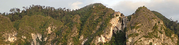
1)Study sites: We focus on a typical lowland landscape in East Kalimantan that includes intact natural forests, secondary forests following fire or cutting, plantation forests, and grasslands. The fieldwork will be based at the exercise forest of East Kutai Agricultural College School, and several other forests, plantations, and grasslands in East Kutai Region, East Kalimantan.
2)Tree communities: The lowland tropical rainforest in Borneo contains one of the richest assemblages of flora in the humid tropics. This species richness has been greatly supported by the complexity of the forest structure. We establish several plots in each landscape at the study sites. We measure the diameter of tree trunks at ca. 1.2 m high (diameter at breast height: DBH) with a DBH of >10 cm and identified the species. In addition, we measure the height of the highest tree in each plot. We describe the forest maturity levels from the collected tree community data, such as tree size and volume ratio of pioneer tree species.
3)Necrophagous dung beetles: Dung beetles (coprophagous group of Scabaeoidea) are known as being a superior indicator of both habitat quality and environmental change in forests and the surrounding environments in tropical regions. Necrophagous dung beetles, which feed on carrion, have important ecological functions, including promoting the rapid decomposition of carcasses, in addition to influencing nutrient cycling, bioturbation, plant growth enhancement, and parasite (fly) control. The level of these ecosystem services is related to the biomass (dry weight) of the beetles collected by traps. We collect beetles using pitfall traps baited with raw fish. We describe the beetle diversities from the collected beetle community data. We also weigh the total dry weight of the collected beetles and report it as the biomass.
4)Parasitic wasps and bees: Parasitic wasps, as natural enemies of various moths, beetles, flies, and other insects, play a major role in regulating populations of forest insects. The diversity of parasitic wasps is linked with the maintenance of stable ecosystems of the tropical rain forests. Bees (Hymenoptera: Apoidea) are adapted to feed on nectar and pollen. They have important functions as pollinators of flowers and help maintain the complex plant diversity in tropical rain forests. We collect both wasps and bees in yellow pan traps baited with honey. We describe their diversities from the collected wasp and bee community data.
5)Distribution of orangutans: Orangutans are an endangered species living in intact natural forests in Borneo and Sumatra, and their conservation is one of the most important subjects of conservation biology. Orangutans rely on large rain forests for survival, but the rain forests have become fragments by practices such as logging. One of the best methods to conserve this species is by maintaining their habitat through connecting the forest fragments. To this end, we need to determine the current residence status of orangutans; however, this is difficult to achieve because of the low density of this species and we must estimate their residence using satellites. We collect data on the residence of orangutans through observation of their nests and by asking people who manage and/or live near forests.
6)Developing models estimating biodiversity and preparing a biodiversity map: To estimate biodiversity from satellite images, we develop a model formula that estimates forest maturity levels, the diversities and ecosystem services of insects, and the residence status of orangutans through analyses of the relationships between field data and indices derived from satellite images. Next, we estimate them by substituting the index values derived from the satellite images with the developed model in the whole lowland area of East Kalimantan. Finally, we prepare a biodiversity map using GIS.
7. Scientific Achievement
Due to the impact of the new coronavirus, we were only able to collect diversity data for two years, which was scheduled to take place over three years. Analyzing the obtained biodiversity data, we found that the species richness of trees and dung beetles, and the abundance of dung beetles were as follows: healthy forest (primitive natural forest) > secondary forest > rubber plantation > oil palm plantation ≒ grassland. The community structure of dung beetles was broadly divided into three areas: healthy forest, rubber/oil palm plantation, and grassland, and secondary forest was divided into a community close to healthy forest and a community close to rubber/oil palm plantation. Other ground-dwelling beetles were abundant in rubber plantations and grasslands, and the species richness of bees were high in healthy forests, secondary forests, and grasslands. Orangutans were only recorded in healthy forests. Sentinel2 satellite images (Level 2A) taken from January 1 to December 31, 2023 were used to calculate explanatory variables used in a mathematical model with the diversity data as objective variables. We obtained a mosaic image generated on GoogleEarthEngine using the median value of images with cloud cover of 60% or less for the survey area, and calculated several index values using the 12 observation band values (reflectance of B1 to B12). In addition, the resolution (pixel) of each band of Sentinel2 is 10 to 60 m, so we calculated the average value of each index by increasing the size of the survey plot by 1 pixel in the north, south, east, and west to a size of 170 x 170 m. Next, we created an optimal mathematical model to estimate biodiversity by combining ground biodiversity data and satellite image data, and created wide-area maps of maximum tree heights, species richness of dung beetles, and other data that showed strong correlations between predicted and measured values (Fig. 1).
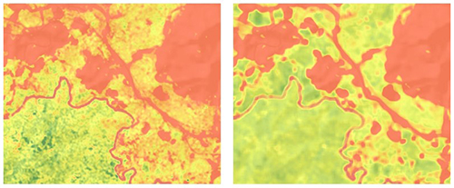
Fig.1 Parts of biodiversity estimation maps created using a mathematical model (near Sangatta City, East Kalimantan). Left: maximum tree height, right: number of dung beetle species. Darker shades of green denote greater tree height and increased species richness of dung beetles. The majority of the orange area represents open-cut coal mining regions, alongside rivers, roads, urban areas, and grasslands.
8. Applications
The results of this research will contribute to measures for biodiversity conservation in East Kalimantan, such as establishing protected forests.
9. Publications
Sakai A, Arbain, Sugiarto, Rahmawati K, Mirmanto E, Takahashi M, Ueda A (2022) Composition and diversity of tree species after fire disturbance in a lowland tropical forest in East Kalimantan, Indonesia. Biodiversitas 23: 1576-1587.
Ueda A, Dwibadra D, Kahono S, Sugiarto, Ochi T, Kon M (2022) Atlas of dung beetles collected in the Sungai Wain Protection Forest and its surroundings in the lowlands of Borneo. Bulletin of FFPRI 21: 165-192.
Ueda A, Taki H, Makihara H (2023) Lowland forest in East Kalimantan -Treasury of new species-. Shinringijutsu 970: 26-30 (in Japanese).
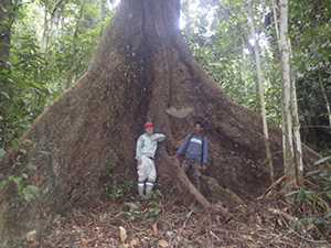
A large tree in the exercise forest of East Kutai Agricultural College School
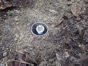
Fish baited pitfall trap
Copyright © Forest Research and Management Organization. All rights reserved.